
WEST LAFAYETTE, Ind. — A Purdue University archaeologist is utilizing drone technology to capture details and data from Bronze Age field sites in Armenia.
"Drones are a new tool in archaeologists' toolkits," said Ian Lindsay, an associate professor of anthropology who has been excavating in the South Caucasus region for 15 years. "It's a good alternative to kites, balloons or sitting in the bucket of a crane with a camera trying to visually document these ancient sites. Drones offer a detailed aerial perspective that we've never had before, and by leveraging this technology archaeologists can be more efficient in the field as drones give us an immediate sense of spatial science scale useful for planning excavation."
Lindsay's 3:49 minute video of various field Armenian sites from this summer is available online. The drone, flying 300 meters from the ground, navigated the valleys and mountains of the Tsaghkahovit Plain and Mt. Aragats region to provide a view that is better quality and less expensive than images captured by satellite or mapping imagery. Lindsay is co-director of Project ArAGATS, Archaeology and Geography of Ancient Transcaucasian Societies, that focuses on the exploration of southern Caucasia's rich past and the preservation of modern Armenia's diverse cultural heritage.
Funds from Purdue's College of Liberal Arts and Office of Executive Vice President for Research and Partnerships supported the new drone technology. Lindsay also is collaborating with Adam T. Smith, Cornell University professor and co-director of the Project ArAGATS, and the Aragats Foundation, which encourages and supports archaeological tourism, education and development in Armenia.
In addition to the spatial analysis of the hilly region, Lindsay also was able to use the drone images to count burials from the late Late Bronze Age, dating to 1500 BCE, a time period contemporary to King Tut in Egypt.
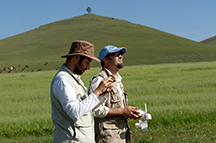 |
Ian Lindsay, a Purdue associate professor of anthropology, flies a drone alongside colleague Alan Greene from Stanford University. The hilltop fortress of Aragatsi Berd is in the background, with a modern TV antennae on top of it. (Photo provided by Project ArAGATS)
Download Photo |
The societies of the South Caucasia society were mobile - pastoralists who cared for livestock - so they didn't leave a strong footprint other than cemeteries and fortresses which may have housed their leaders. These fortresses were built with extremely large stone boulders and on ridges overlooking plains and valleys. Because only the lower courses of the foundation walls are preserved, researchers do not know the height of the structures. Ancient remains and artifacts, including a shrine enclosed within a stone room of a fortress, can be found up to 2 meters underground, but there are some visible surface features.
"I'm interested in how mobile pastoralists coalesce into larger political structures," Lindsay said. "This group was mobile, so what brought them back to these fortresses to pay their tithing and support the local political structure? Artifacts show these places were homes to ritual, and ritual is an important form of soft power that may have encouraged people to return seasonally to support the fortresses' institutions and leaders."
Lindsay also is interested in the development of metal production in the area, as well as trade and communication routes through the hilly region.
In addition to utilizing the drone technology this summer, Lindsay was able to test a new iPad-based mobile GIS (geographic information system) data collection system and mobile data collection app that he and Nicole Kong, an assistant professor of library science who specializes in GIS, developed to inventory new sites.
"This will be a collaborative tool for archaeologists in the region to add and edit data about field sites," Lindsay said. "It also will be helpful to update legacy sites, which are sites that were identified or excavated but have not yet been published. Again, it's another tool to help scientists be more efficient in the field."
Funds from the College of Liberal Arts and the Executive Vice President for Research and Partnerships also supported the GIS data collection system.
Writer: Amy Patterson Neubert, 765-494-9723, apatterson@purdue.edu
No comments:
Post a Comment