POSTED IN: NEWS
A set of documents, brought to United States by an Italian immigrant, may reveal new details about Marco Polo’s travels in Asia, including that he possibly explored and mapped Alaska.
Marco Polo (1254-1324) was a Venetian merchant who wrote a detailed account of his travels into Asia, where he spent over 20 years, including being in the service of the Mongol ruler Qubilai Khan. His work, known as the Book of the Marvels of the World, was one of the most famous accounts of Eastern Asia from the Middle Ages, although Marco noted that “I did not tell half of what I saw.”
Besides his account of his travels of Asia, very little is known about Marco Polo. It seems that a set of fourteen documents might offer some new insights into his life. They are detailed in the new book The Mysteries of the Marco Polo Maps , by Benjamin Olshin, which is to be published next month by the University of Chicago Press. This historian has been researching these documents for thirteen years, and revealed some of his findings in the article ‘The Mystery of the “Marco Polo” Maps: An Introduction to a Privately-Held Collection of Cartographic Materials Relating to the Polo Family,’ which appeared in the journal Terrae Incongnitae in 2007.
Olshin examined 14 documents that were brought to the United States by Marcian F. Rossi, an Italian immigrant, who claimed that they had been passed down through his family for generations. In the 1930s he gave a short account of these documents to a scholar named Leo Bagrow:
Marco Polo entrusted the maps to Admiral Rujerius Sanseverinus who had graduated the Nautical School at Amalfi. A number of centuries later his descendant Ruberth Sanseverinus married Elisabeth Feltro Della Rovere, Duchess of Urbino. In the year 1539 Julius Cesare de Rossi, Count of Bergeto, married Maddalena Feltro Della Rovere Sanseverinus to whom the Tenure of Cajiata was assigned; his grand-son Joseph de Rossi became Duke of Serre; this tenure was held till 1744, when it was transferred to the Duchy of Casale to [at?] Joseph de Rossi; his younger brother Antonio de Rossi was the father of Marciano de Rossi, my great grandfather…
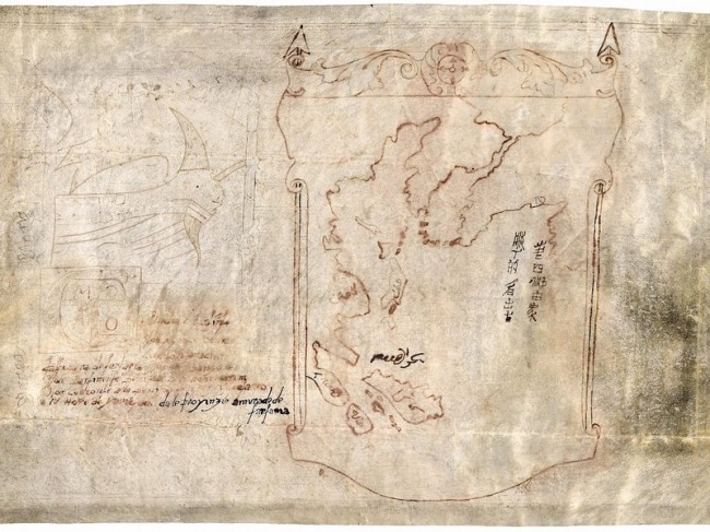
The documents have now been passed down to his great-grandson, Jeffrey Pendergraft, except for one parchment that was donated to the Library of Congress. This last document, known as the ‘Map with Ship’ shows a map of eastern Asia and what appears to be part of Alaska. It also contains writing in Chinese, Arabic and Latin that offers some notes on various places on the map. Recent radiocarbon dating of this parchment reveals that it dates to the 15th or 16th centuries, meaning that it could be a copy of the original or a forgery
The other documents include writings purported to be made by the daughters of Marco Polo. In the one allegedly by Bellela Polo, she offers a story not included in the Book of the Marvels of the World:
 After Master Polo had become known in all of China for his zeal, the wife of Fafur, queen of the women in the province of the Mangi, entrusted to him a message for Fusint, queen of the women in the Far East, and put him in command of twenty Chinese and Saracen sailors, and with a big ship he set sail from the Gulf of [the] Manji and along the chain of small islands that cross the promontory on the east side of that gulf and then navigated to the east. Then he entered the ocean where suddenly there arose such a terrible storm that the compass needle swung from this side to that, forcing him to sail to the north side of a chain of islands that enclosed the sea, and stretched east as far as a peninsula where Master Marco Polo disembarked from the ship twenty-eight days after having departed from China.
It also notes that they came across “people who speak the Tartar language, and … go about dressed in sealskins, living on fish …” If this story is true, it is possible that Marco Polo sailed to the Aleutian Islands, where he met with aboriginals.
Olshin notes that there are many questions about the authenticity of these documents. If they are forgeries, it would have had to be done by someone able to write Italian, Latin, Chinese, and Arabic, as well as have a good knowledge of cartography. It is unlikely that this was Marcian Rossi, who went to become a tailor in California but had little formal education.
The Mysteries of the Marco Polo Maps should provide readers with more details about these documents and help start more research into the possibility that Marco Polo reached parts of North America. You can learn more about the book from University of Chicago Press.
See also the article Did Marco Polo “Discover” America? from the Smithsonian.com
1 comment:
Given the countries and the cultures described in the documents it appears that Marco Polo's journey to the
New World was not following a random path but was
using the currents of the North Pacific Gyre to expedite
his progress. Dr. Joseph Needham has reported that
this current was known by the Chinese since ancient times as the Wei Lu Current. In the 5th Century (800
years before Marco Polo) Buddhist cleric Hwui Shan also took this same course to a place the Chinese had known of for millennia and called Fu Sang. Upon his return to China Hwui Shan gave his report to Chinese Emperor Wu Ti which was recorded in the official Chinese record and is still available for review today. Given Hwui Shan's descriptions of the countries and cultures he encountered on his way to Fu Sang (which appear almost identical to those in Marco Polo account) it seems that both these men used the North Pacific Gyre to expidite their way to the New World although 800 years apart.
Post a Comment